Our region

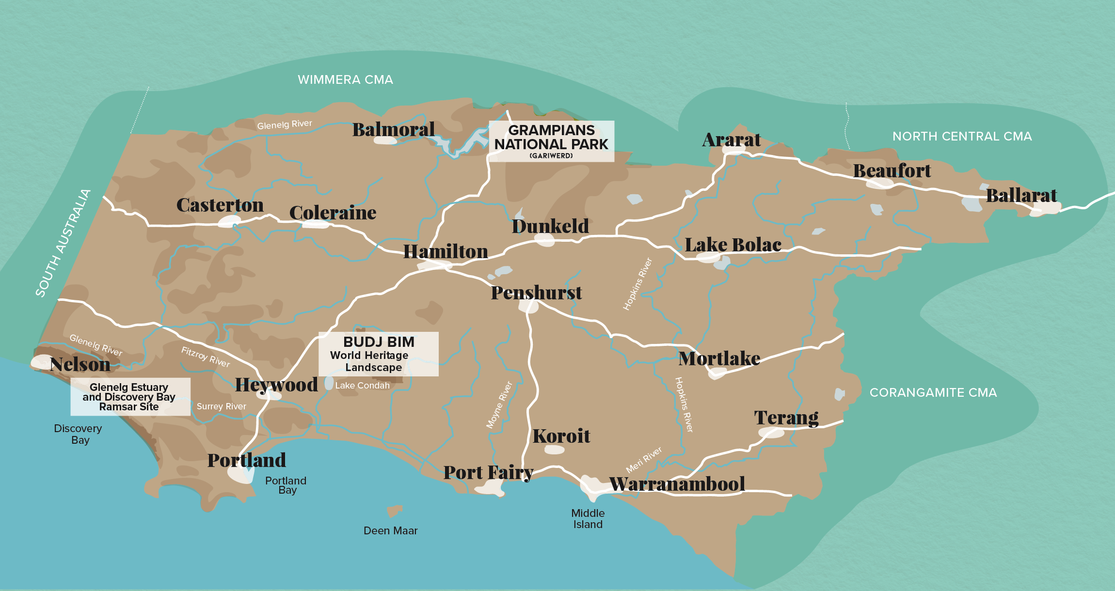
The region’s 26,910 km square kms includes the cities and townships of Ballarat, Hamilton, Warrnambool, Ararat, Casterton, Mortlake, Port Fairy, Beaufort and Portland. There are four basins in the region: Glenelg, Millicent, Hopkins and Portland Coast.
The boundaries of the region include marine and coastal waters out to the state limit of three nautical miles. The south has flat volcanic plains, while the Grampians, Dundas tablelands, Black Ranges and Central Highlands dominate the north.
Read more about our our region in the 2021-2027 Regional Catchment Strategy
Building blocks for a healthy and resilient landscape
Our community, water, biodiversity, land, and marine and coast are the main building blocks for a healthy and resilient regional landscape.
Land
The Glenelg Hopkins region is recognised as having some of the most fertile and productive soils in Australia More
See our Land & Sustainable agriculture projects
GHCMA RCS WEBSITE (links to website)
Read more about our Land management plan in the 2021-2027 Regional Catchment Strategy
Water
Water is essential for maintaining life and also underpins the economy of the region, supporting agriculture, manufacturing and tourism. More
See our Waterways projects
GHCMA RCS WEBSITE (links to website)
Read more about our Water management plan in the 2021-2027 Regional Catchment Strategy
Biodiversity
The region supports a diverse array of species, ecological communities, and ecosystems. More
See our Biodiversity projects
GHCMA RCS WEBSITE (links to website)
Read more about our Biodiversity management plan in the 2021-2027 Regional Catchment Strategy
Community
Aboriginal people across the region have retained a strong identity and connection to their traditional lands for which they have custodial rights and responsibilities. More
See our Community projects
GHCMA RCS WEBSITE (links to website)
Read more about our Community plan in the 2021-2027 Regional Catchment Strategy
Marine & coast
The Glenelg Hopkins region is characterised by its dramatic coastline, with towering cliffs and extensive dune systems carved out by changing sea levels, volcanic activity, and wind and water erosion. More
See our Marine & Coastal projects
GHCMA RCS WEBSITE (links to website)
Read more about our Marine & coast management plan in the 2021-2027 Regional Catchment Strategy


